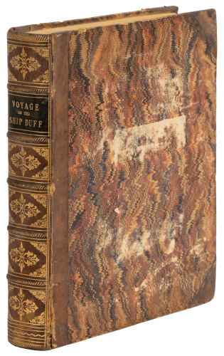
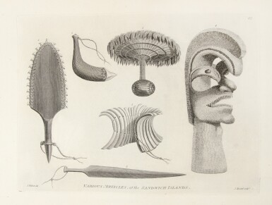
Title: A Voyage to the Pacific Ocean...for making Discoveries in the Northern Hemisphere. To determine the Position and Extent of the West Side of North America; its Distance from Asia; and the Practicability of a Northern Passage to Europe. Performed under the Direction of Captains Cook, Clerk, and Gore, in his Majesty's Ships the Resolution and Discovery, In the Years 1776, 1777, 1778, 1779, and 1780 Author: Cook, James and James King Place: London Publisher: Printed by W. and A. Strahan for G. Nicol and T. Cadell Date: 1784 Description: Three text volumes and Atlas volume. Text Volumes: [8], xcvi, 421; [12], 549; [12], 558, + [1] ad pp. Illustrated with 24 copper-engraved maps, charts and profile views (13 folding) and a folding letterpress table. (4to) 11¼x8½, period tree calf, rebacked with modern calf, tooled in gilt, morocco lettering pieces, marbled endpapers. Atlas: With 2 folding charts (of the world and of the coasts of Northwestern America and Northeastern Asia) and 61 copper-engraved plates, mostly after J. Webber. 22x16¼, period half calf & marbled boards. Together, 4 volumes. First Edition. First edition of Cook's third voyage, in which the Sandwich Islands [now Hawaiian Islands] are discovered. Cook would be killed by the initially friendly natives of Hawaii. Also, in Cook's search for the Northwest Passage, he surveyed the straits between Asia and America and ascertained the proximity between them, and there is much information on the northwest coast of North America, Alaska, Kamchatka, and other northern climes. The first two volumes were the work of Cook himself, the third was completed by Captain James King The publication of this official account was much delayed, and, according to Holmes, "it was so eagerly awaited by the public that it was sold out on the third day after publication". Forbes declares the work to be "arguably the single most important book on the Hawaiian Islands" which "documents all aspects of Hawaiian culture at the point of discovery by Europeans. It is a magnificent summation of all the public and private journals, logs, drawings, and other observations made during the course of the voyage and is as important a record of the exploration of the North Pacific as Cook's first two voyages had been for the South Pacific." He further notes that twelve of the plates in the atlas relate to Hawaii, as do two of the charts in the text volumes. Forbes 62; Holmes 47; Howes C729a; Lada-Mocarski 37; Sabin 16250. Lot Amendments Condition: Some corner and edge wear to text volumes; offsetting from the plates in the text volumes, marginal darkening to titles, former ink names to titles erased, replaced with pencil ones (Macdonald?), repair to p.xcvi in Vol. I; atlas covers worn, detached, some mostly marginal foxing and occasional marginal dampstains to plates, lower corner of one plate in atlas replaced, well away from image, plate of polar bear creased, lacks one interleaf; overall very good, the impressions of the plates quite clear and crisp. Item number: 174059
Title: A Voyage to the Pacific Ocean...for making Discoveries in the Northern Hemisphere. To determine the Position and Extent of the West Side of North America; its Distance from Asia; and the Practicability of a Northern Passage to Europe. Performed under the Direction of Captains Cook, Clerk, and Gore, in his Majesty's Ships the Resolution and Discovery, In the Years 1776, 1777, 1778, 1779, and 1780 Author: Cook, James and James King Place: London Publisher: Printed by W. and A. Strahan for G. Nicol and T. Cadell Date: 1784 Description: Three text volumes and Atlas volume. Text Volumes: [8], xcvi, 421; [12], 549; [12], 558, + [1] ad pp. Illustrated with 24 copper-engraved maps, charts and profile views (13 folding) and a folding letterpress table. (4to) 11¼x8½, period tree calf, rebacked with modern calf, tooled in gilt, morocco lettering pieces, marbled endpapers. Atlas: With 2 folding charts (of the world and of the coasts of Northwestern America and Northeastern Asia) and 61 copper-engraved plates, mostly after J. Webber. 22x16¼, period half calf & marbled boards. Together, 4 volumes. First Edition. First edition of Cook's third voyage, in which the Sandwich Islands [now Hawaiian Islands] are discovered. Cook would be killed by the initially friendly natives of Hawaii. Also, in Cook's search for the Northwest Passage, he surveyed the straits between Asia and America and ascertained the proximity between them, and there is much information on the northwest coast of North America, Alaska, Kamchatka, and other northern climes. The first two volumes were the work of Cook himself, the third was completed by Captain James King The publication of this official account was much delayed, and, according to Holmes, "it was so eagerly awaited by the public that it was sold out on the third day after publication". Forbes declares the work to be "arguably the single most important book on the Hawaiian Islands" which "documents all aspects of Hawaiian culture at the point of discovery by Europeans. It is a magnificent summation of all the public and private journals, logs, drawings, and other observations made during the course of the voyage and is as important a record of the exploration of the North Pacific as Cook's first two voyages had been for the South Pacific." He further notes that twelve of the plates in the atlas relate to Hawaii, as do two of the charts in the text volumes. Forbes 62; Holmes 47; Howes C729a; Lada-Mocarski 37; Sabin 16250. Lot Amendments Condition: Some corner and edge wear to text volumes; offsetting from the plates in the text volumes, marginal darkening to titles, former ink names to titles erased, replaced with pencil ones (Macdonald?), repair to p.xcvi in Vol. I; atlas covers worn, detached, some mostly marginal foxing and occasional marginal dampstains to plates, lower corner of one plate in atlas replaced, well away from image, plate of polar bear creased, lacks one interleaf; overall very good, the impressions of the plates quite clear and crisp. Item number: 174059

.jpg)


.jpg)
.jpg)


Testen Sie LotSearch und seine Premium-Features 7 Tage - ohne Kosten!
Lassen Sie sich automatisch über neue Objekte in kommenden Auktionen benachrichtigen.
Suchauftrag anlegen