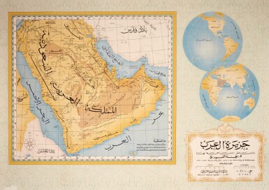
AN ARABIC MAP OF THE WORLD. [Probably Egypt; Mamluk, c. 1400] Illuminated manuscript world map, 269 x 181mm (leaf). The map is an hemispherical projection with South at the top, drawn in red and black ink. The seven climes are indicated by parallel red lines running across the world, the map showing the continents of Asia, Africa and Europe, from Africa to China and including stylised oval depictions in blue of the Caspian Sea and source of the Nile, with the rivers Euphrates, Nile, Tigris and Mediterannean and Indian Ocean all in blue. The map set in a simple ruled border heightened with gold bisected on each side with the cardinal points, and within the border four geometric roundels hand-coloured in blue and red and heightened in gold, the verso with 25 lines of text in Arabic in black and red ink. (Some light discolouration, a few small marginal stains on the verso.) A very rare and fine 'Manumic-style' map, having the principal characteristics of world maps inspired or after a purported world map produced under the patronage of the seventh Abbasid caliph, Mamun (813-833 AD). The twelth-century descriptive geographer, Zuhri, records Mamun's direction of some seventy scientists in the design of 'New World Map', and the tenth century 'Herodotus of the Arabs', Masudi (885-957), recounts a visit he made to Bayt-al-Hikmah, where he saw the product of Mamun's cartographers. Mamun's map no longer survives, and its exact form remains a matter of conjecture, but it was almost certainly based on Ptolomaic traditions of cartography, showing only the northern hemisphere. The encircling of the world by oceans was an idea put forward by Eratosthenes (276-194 BC), and was prevalent in Hellenic cartography in the third and second centuries BC, as we know from the writings of Strabo (63 BC - 24 AD). The inclusion of only the northern hemisphere is usual in Ptolomaic maps, since, although Ptolomy considered the world to be a sphere, it was inconceivable that the underside of the planet was inhabitable. Ptolemy himself represented the world on a 180° projection only. The seven- climata system was based on a Ptolomaic method of indicating the boundaries between climata based on calculations of latitude, although he himself produced twenty-four climes calculated from measurments made of shadows of the gnomon or the midsummer day. They were generally intended to indicate the centrality of the Arabic world, and to orientate the various parts of the world in relation to one another. The present map also is divided into four principal sections, with place names predominant in the area marked with the seven climes. Other areas, such as north of the Caspian Sea and Africa bear inscipritions such as 'unknown place'. The seven- climata system had another function: to indicate simply the degree to which peoples were coloured in relation to their proximity to the furthermost points of the world in a northerly or southerly direction. The author of the present map does not identify himself, but this map conforms in style to the Balkhi School. However, as Harley and Woodward discusss ( The History of Cartography , vol. 2, book 1, pp. 124-128), the Balkhi School is not one idetnifiable group, composed as it is of maps relating closely to the work of al-Istakhri, and to the Ibn Hawqal I type. Work produced in Balkhi School style was produced over a period of some six hundred years, with examples being produced as late at the 1670s. The present map is related to al-Idii's world map from the Oxford Pococke manuscript (MS Pococke 375, fols. 3v-4r), dated 1456, where the same colouring and the use of red and black ink can also seen. There are, however, substanital differences. The present map is simpler in the presentation of the geography, whilst the only topographical features to be included are rivers. The form and size of Africa, the over-sized Indian Ocean (or Persian Sea, as it is sometimes labelled), and the absence of any islands, suggests that the pr
AN ARABIC MAP OF THE WORLD. [Probably Egypt; Mamluk, c. 1400] Illuminated manuscript world map, 269 x 181mm (leaf). The map is an hemispherical projection with South at the top, drawn in red and black ink. The seven climes are indicated by parallel red lines running across the world, the map showing the continents of Asia, Africa and Europe, from Africa to China and including stylised oval depictions in blue of the Caspian Sea and source of the Nile, with the rivers Euphrates, Nile, Tigris and Mediterannean and Indian Ocean all in blue. The map set in a simple ruled border heightened with gold bisected on each side with the cardinal points, and within the border four geometric roundels hand-coloured in blue and red and heightened in gold, the verso with 25 lines of text in Arabic in black and red ink. (Some light discolouration, a few small marginal stains on the verso.) A very rare and fine 'Manumic-style' map, having the principal characteristics of world maps inspired or after a purported world map produced under the patronage of the seventh Abbasid caliph, Mamun (813-833 AD). The twelth-century descriptive geographer, Zuhri, records Mamun's direction of some seventy scientists in the design of 'New World Map', and the tenth century 'Herodotus of the Arabs', Masudi (885-957), recounts a visit he made to Bayt-al-Hikmah, where he saw the product of Mamun's cartographers. Mamun's map no longer survives, and its exact form remains a matter of conjecture, but it was almost certainly based on Ptolomaic traditions of cartography, showing only the northern hemisphere. The encircling of the world by oceans was an idea put forward by Eratosthenes (276-194 BC), and was prevalent in Hellenic cartography in the third and second centuries BC, as we know from the writings of Strabo (63 BC - 24 AD). The inclusion of only the northern hemisphere is usual in Ptolomaic maps, since, although Ptolomy considered the world to be a sphere, it was inconceivable that the underside of the planet was inhabitable. Ptolemy himself represented the world on a 180° projection only. The seven- climata system was based on a Ptolomaic method of indicating the boundaries between climata based on calculations of latitude, although he himself produced twenty-four climes calculated from measurments made of shadows of the gnomon or the midsummer day. They were generally intended to indicate the centrality of the Arabic world, and to orientate the various parts of the world in relation to one another. The present map also is divided into four principal sections, with place names predominant in the area marked with the seven climes. Other areas, such as north of the Caspian Sea and Africa bear inscipritions such as 'unknown place'. The seven- climata system had another function: to indicate simply the degree to which peoples were coloured in relation to their proximity to the furthermost points of the world in a northerly or southerly direction. The author of the present map does not identify himself, but this map conforms in style to the Balkhi School. However, as Harley and Woodward discusss ( The History of Cartography , vol. 2, book 1, pp. 124-128), the Balkhi School is not one idetnifiable group, composed as it is of maps relating closely to the work of al-Istakhri, and to the Ibn Hawqal I type. Work produced in Balkhi School style was produced over a period of some six hundred years, with examples being produced as late at the 1670s. The present map is related to al-Idii's world map from the Oxford Pococke manuscript (MS Pococke 375, fols. 3v-4r), dated 1456, where the same colouring and the use of red and black ink can also seen. There are, however, substanital differences. The present map is simpler in the presentation of the geography, whilst the only topographical features to be included are rivers. The form and size of Africa, the over-sized Indian Ocean (or Persian Sea, as it is sometimes labelled), and the absence of any islands, suggests that the pr






Testen Sie LotSearch und seine Premium-Features 7 Tage - ohne Kosten!
Lassen Sie sich automatisch über neue Objekte in kommenden Auktionen benachrichtigen.
Suchauftrag anlegen