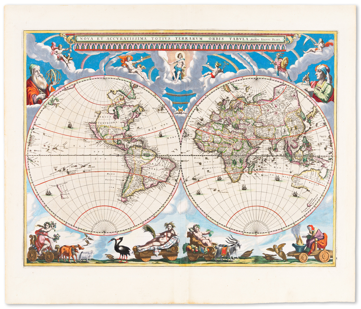
BLAEU, Johannes. Nova Totius Terrarum Orbis Tabula...emendata a F.de Wit . Letterpress text signed Amsterdam, L'Imprimerie de Jean Blaeu, map with imprint Gedrucht Tot Amsterdam by Frederick de Wit Kaert en Konst Verkooper Inde Kalverstraet by den dam Inde Witte Paskaert. [ca. 1665-66]. Hand-coloured engraved wall-map of the world on 21 map sheets, with 10 sheets of letterpress description pasted below the lower margin, overall size (including text) 2020 x 3010mm. The double-hemisphere world map partially hand-coloured, coastlines partly coloured in outline, title band in blue, border decoration in blue and red, the map with two dedicatory cartouches, numerous wind-roses and ship scenes, the border decoration comprising at upper corners, celestial hemispheres, at the lower corners, north and south polar projections of the world, directly below the map is a dedicatory portrait of Louis XIV with a map of the ancient world, representations of the planetary systems of Ptolemy and Brahe, and the de Wit address below, the borders filled with clouds and some allegorical figures, coloured in red and blue. The title cartouche and map bordered in an architectural 'frame surround', the lower margin with a 10 sheet letterpress description in Latin and French, each sheet comprising two columns of letterpress text. (The map browned and neatly restored, the restoration mostly confined to the margins and letterpress descriptions which include careful manuscript replacements of the lettering, a few small areas of the interior map of the map with minor replacements, the wall-map mounted on new cloth, old stab holes for previous stretchers affecting upper and lower margins.) AN UNRECORDED THIRD STATE OF THE DE WIT REISSUE OF JOHANNES BLAEU'S IMPORTANT WALL-MAP OF THE WORLD. This rare copy is unknown to cartobibliographers and appears to be a unique survival of this issue, probably the only example of the Blaeu wall-map in private hands, and certainly the only example to be offered to the market since a copy of the first state was sold by H.P.Kraus to the University of Texas in 1969. Apart from this copy, 11 other examples of all states of this wall-map are known, all in libraries and museums. The history of the Blaeu family wall-maps of the World began in 1619 with the issue of Willem Blaeu's important world map on 21 sheets, reissued in 1645-46. This map survives in a single example in the Maritime Museum in Rotterdam and the resissue also in one example in the same museum. Johannes Blaeu, emulating his father, re-engraved the world map on 21 sheets in 1648, adding the latest information available to him as chief cartographer to the VOC, creating an outline of the world copied by cartographers to the end of the century. Six copies of the first state survive. A second state, probably issued in the mid 1650's incorporates new information on China gathered from the Jesuit M. Martini (2 examples known). It appears that around 1665 the plates were obtained by the young Frederick de Wit (1630-1706), in fact he had only just joined the Guild of St Luke in 1664. De Wit reissued the wall-map with a new dedicatory portrait to Louis XIV, and with letterpress text in French. Up until now, as Shirley 371 records, the only known examples of this third issue are two copies in the Bibliotheque Nationale, both are missing the address of de Wit and the map of the ancient world is unfinished. This copy would now be the considered as the correct third state with these two examples being early pulls of the plates, perhaps sent to the Court of France for approval, or perhaps the inclusion of the de Wit address was considered too commercial for a royal presentation. Shirley postulates the existence of the present state of the wall-map with the de Wit imprint because of the survival of a fourth state of the map with the imprint of Nicolas Visscher on the title and the de Wit address below the portrait. Shirley records one example of this imprint in the National Mus
BLAEU, Johannes. Nova Totius Terrarum Orbis Tabula...emendata a F.de Wit . Letterpress text signed Amsterdam, L'Imprimerie de Jean Blaeu, map with imprint Gedrucht Tot Amsterdam by Frederick de Wit Kaert en Konst Verkooper Inde Kalverstraet by den dam Inde Witte Paskaert. [ca. 1665-66]. Hand-coloured engraved wall-map of the world on 21 map sheets, with 10 sheets of letterpress description pasted below the lower margin, overall size (including text) 2020 x 3010mm. The double-hemisphere world map partially hand-coloured, coastlines partly coloured in outline, title band in blue, border decoration in blue and red, the map with two dedicatory cartouches, numerous wind-roses and ship scenes, the border decoration comprising at upper corners, celestial hemispheres, at the lower corners, north and south polar projections of the world, directly below the map is a dedicatory portrait of Louis XIV with a map of the ancient world, representations of the planetary systems of Ptolemy and Brahe, and the de Wit address below, the borders filled with clouds and some allegorical figures, coloured in red and blue. The title cartouche and map bordered in an architectural 'frame surround', the lower margin with a 10 sheet letterpress description in Latin and French, each sheet comprising two columns of letterpress text. (The map browned and neatly restored, the restoration mostly confined to the margins and letterpress descriptions which include careful manuscript replacements of the lettering, a few small areas of the interior map of the map with minor replacements, the wall-map mounted on new cloth, old stab holes for previous stretchers affecting upper and lower margins.) AN UNRECORDED THIRD STATE OF THE DE WIT REISSUE OF JOHANNES BLAEU'S IMPORTANT WALL-MAP OF THE WORLD. This rare copy is unknown to cartobibliographers and appears to be a unique survival of this issue, probably the only example of the Blaeu wall-map in private hands, and certainly the only example to be offered to the market since a copy of the first state was sold by H.P.Kraus to the University of Texas in 1969. Apart from this copy, 11 other examples of all states of this wall-map are known, all in libraries and museums. The history of the Blaeu family wall-maps of the World began in 1619 with the issue of Willem Blaeu's important world map on 21 sheets, reissued in 1645-46. This map survives in a single example in the Maritime Museum in Rotterdam and the resissue also in one example in the same museum. Johannes Blaeu, emulating his father, re-engraved the world map on 21 sheets in 1648, adding the latest information available to him as chief cartographer to the VOC, creating an outline of the world copied by cartographers to the end of the century. Six copies of the first state survive. A second state, probably issued in the mid 1650's incorporates new information on China gathered from the Jesuit M. Martini (2 examples known). It appears that around 1665 the plates were obtained by the young Frederick de Wit (1630-1706), in fact he had only just joined the Guild of St Luke in 1664. De Wit reissued the wall-map with a new dedicatory portrait to Louis XIV, and with letterpress text in French. Up until now, as Shirley 371 records, the only known examples of this third issue are two copies in the Bibliotheque Nationale, both are missing the address of de Wit and the map of the ancient world is unfinished. This copy would now be the considered as the correct third state with these two examples being early pulls of the plates, perhaps sent to the Court of France for approval, or perhaps the inclusion of the de Wit address was considered too commercial for a royal presentation. Shirley postulates the existence of the present state of the wall-map with the de Wit imprint because of the survival of a fourth state of the map with the imprint of Nicolas Visscher on the title and the de Wit address below the portrait. Shirley records one example of this imprint in the National Mus


.jpg)


Testen Sie LotSearch und seine Premium-Features 7 Tage - ohne Kosten!
Lassen Sie sich automatisch über neue Objekte in kommenden Auktionen benachrichtigen.
Suchauftrag anlegen