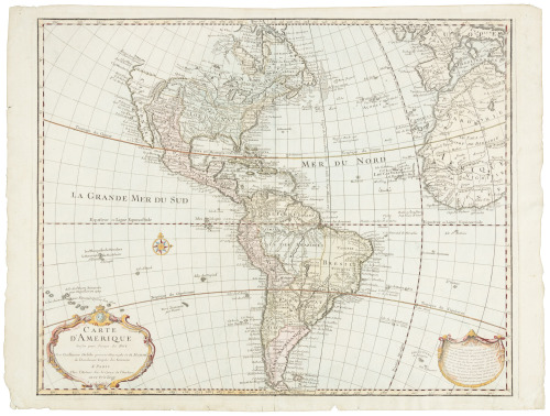
Title: Carte d'Amerique, dressée pour l'usage du Roy. Par Guillaume Delisle premier Géographe de Sa Majesté de l'Academie Royale des Sciences Author: De l'Isle, Guillaume Place: Amsterdam Publisher: Jean Covens & Corneille Mortier Date: 1722-1739 Description: Copper-engraved map, hand-colored in outline. 48x60 cm. (18¾x23½"). Covens & Mortier's fine reissue of De l'Isle's 1722 map of North and South America, basically unchanged though re-engraved. Printed on thick paper with an excellent impression. The caption in top border reads "America accurate in Imperia, Regna Status & Populos Divisa ..." For California, the west coast is taken north to Cap Mendocin and Cap Blanc, with the notation, "Entrée decouverte par Martin d'Aguilar." Wagner notes "Briggs names with some of the corrections made by Blaeu. The Mediterranean Sea of California has disappeared. Delisle retained Cabrillo's B. de Pinos and introduced a few, the I. Ste Anne, the B. de St. Martin, and the B. de la Medelaine, from other maps. It seems likely that he had read the account of the Vizcaino expedition Torquemada... On the Sonora coast the names are much the same as those on his 1700 map with a few additions from Kino's map and other sources in Sonora..." Tooley describes this issue of the De l'Isle map as "Re-engraved though the map remains basically unchanged. The lettering within the title cartouche is copied from the issue of the first edition with the florid lettering for d'Amerique." Tooley, Mapping of America, p.13, No. 4, Plate 3 (showing the 1755 Covens & Mortier issue). Lot Amendments Condition: A few faint marginal stains, near fine to fine. Item number: 167329
Title: Carte d'Amerique, dressée pour l'usage du Roy. Par Guillaume Delisle premier Géographe de Sa Majesté de l'Academie Royale des Sciences Author: De l'Isle, Guillaume Place: Amsterdam Publisher: Jean Covens & Corneille Mortier Date: 1722-1739 Description: Copper-engraved map, hand-colored in outline. 48x60 cm. (18¾x23½"). Covens & Mortier's fine reissue of De l'Isle's 1722 map of North and South America, basically unchanged though re-engraved. Printed on thick paper with an excellent impression. The caption in top border reads "America accurate in Imperia, Regna Status & Populos Divisa ..." For California, the west coast is taken north to Cap Mendocin and Cap Blanc, with the notation, "Entrée decouverte par Martin d'Aguilar." Wagner notes "Briggs names with some of the corrections made by Blaeu. The Mediterranean Sea of California has disappeared. Delisle retained Cabrillo's B. de Pinos and introduced a few, the I. Ste Anne, the B. de St. Martin, and the B. de la Medelaine, from other maps. It seems likely that he had read the account of the Vizcaino expedition Torquemada... On the Sonora coast the names are much the same as those on his 1700 map with a few additions from Kino's map and other sources in Sonora..." Tooley describes this issue of the De l'Isle map as "Re-engraved though the map remains basically unchanged. The lettering within the title cartouche is copied from the issue of the first edition with the florid lettering for d'Amerique." Tooley, Mapping of America, p.13, No. 4, Plate 3 (showing the 1755 Covens & Mortier issue). Lot Amendments Condition: A few faint marginal stains, near fine to fine. Item number: 167329


Testen Sie LotSearch und seine Premium-Features 7 Tage - ohne Kosten!
Lassen Sie sich automatisch über neue Objekte in kommenden Auktionen benachrichtigen.
Suchauftrag anlegen