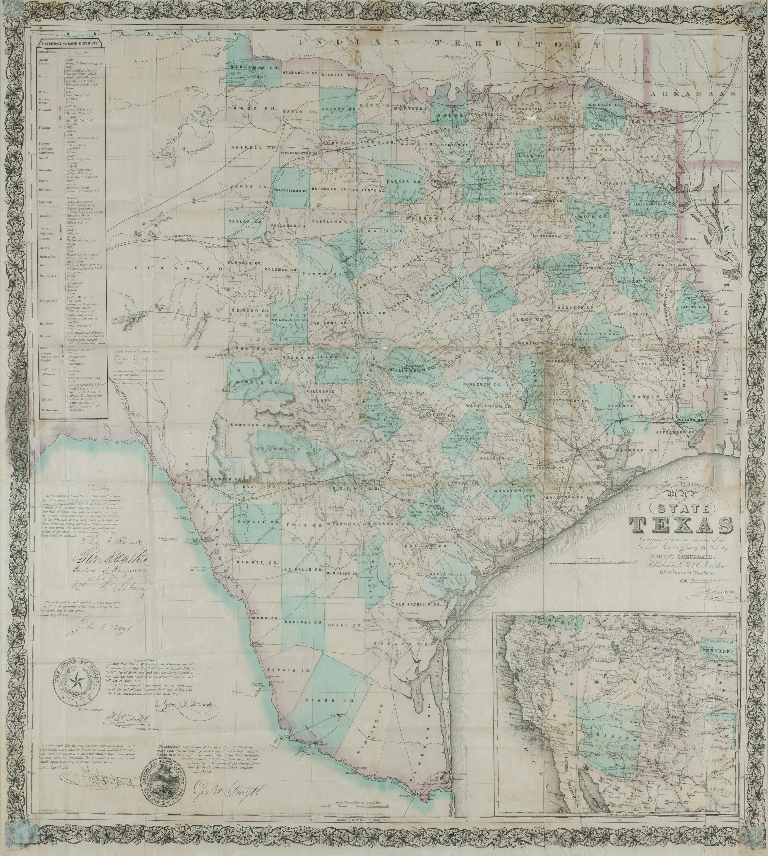
Title: J. De Cordova's Map of the State of Texas Compiled from the Records of the General Land Office of the State, by Robert Creuzbaur, Houston, 1849 Author: De Cordova, Jacob Place: [New York] Publisher: Date: 1849 Description: Copper-engraved map, on four sheets of bank-note paper joined together, hand-colored. With large inset map (23.6x29.5 cm.) of Texas and the surrounding territories. The map is "Engraved by J. M. Atwood, New York"; and "Entered According to Act of Congress on the 28th Day of July 1848 by J. De Cordova/In the Clerk's Office of the United States District Court for the District of Texas." The map is signed in ink by de Cordova. Also appearing are engraved facsimile seals of the state and the general land office and various certifications of accuracy with engraved facsimile signatures. 83x78 cm. (33½x30¾") plus outer border, overall 89x84 cm. (35x33"); folding into original embossed leather folder lettered in gilt, 15.8x10.,8 cm (6¼x4¼"). First Edition. The very rare first edition of Jacob de Cordova's seminal map of Texas, the first official map of Texas as a state, on a far larger scale than any previous map of the state of Texas, and the only of De Cordova’s editions of his Texas map to include the short-lived Santa Fe County (in the untitled oval inset), which comprised much of New Mexico. The map is signed in ink by de Cordova, as issued, beneath the engraved statement "Without my signature all copies of this map have been fraudulently obtained." Of great rarity and exceptional importance, the map is the basis for all future Texas cartography. The brainchild of Jacob de Cordova, a land developer who was active in Texas following its acquisition by the United States, the map was compiled from the latest surveys on a scale never before attempted. Assisting De Cordova was Robert Creuzbaur, an employee of the newly created General Land Office, and the map was one of the first major cartographic productions after annexation to be based upon the records of the General Land Office. The large scale of the map, the great detail, the importance of securing the shifting boundaries of the state, make it a true landmark of Texas cartography. A native of Jamaica, De Cordova was one of the earliest Jewish settlers in Texas. During the War for Texas independence, he supplied goods from New Orleans, and settled in Galveston in 1837. He foresaw a land boom in Texas following the Mexican War, and began speculating in land and working to encourage immigration. As part of his campaign, he produced this first map of Texas in 1849, with a second edition in 1850, and a third in 1851. The untitled inset oval map at lower right, hand-colored, shows Texas in full color, with all or part of Indian Territory, Missouri, Arkansas, Louisiana, New Mexico without the name New Mexico implying it is part of Texas; California stretching to Great Salt Lake, etc. At lower left are seals of Texas and the Texas General Land Office along with certifications and facsimile signatures of Thomas J. Rusk, Sam Houston, David S. Kaufman, and other dignitaries. Further Notes from the Files of Warren Heckrotte Provenance: Maggs, 10/71 References: Basic Texas Books, p. 99; Graff, 920; Phillips, Maps, pp. 844-45; Wheat, Transmississippi, 603; Martin & Martin, Maps of Texas and the Southwest Plate 39, p ii; Fifty Texas Rarities, No. 36. Later issues: 1850. 1851 ( in LC): the map appears identical to 1849 issue, except Cordova'a signature is in plate. On the oval inset, the present state boundaries of Texas are indicated by colored lines, as well as California and territory boundaries, but otherwise appears same. Cpyrt is still 1848. 1853 ( in LC): A number of changes in political and geographical features indicating westward movement; description of boundaries of Fisher-Miller colony are gone. On inset, New Mexico and Utah territories indicated, but not California. Cpyrt is still 1848. 1856 ( in LC): issued by Colton, deleting r
Title: J. De Cordova's Map of the State of Texas Compiled from the Records of the General Land Office of the State, by Robert Creuzbaur, Houston, 1849 Author: De Cordova, Jacob Place: [New York] Publisher: Date: 1849 Description: Copper-engraved map, on four sheets of bank-note paper joined together, hand-colored. With large inset map (23.6x29.5 cm.) of Texas and the surrounding territories. The map is "Engraved by J. M. Atwood, New York"; and "Entered According to Act of Congress on the 28th Day of July 1848 by J. De Cordova/In the Clerk's Office of the United States District Court for the District of Texas." The map is signed in ink by de Cordova. Also appearing are engraved facsimile seals of the state and the general land office and various certifications of accuracy with engraved facsimile signatures. 83x78 cm. (33½x30¾") plus outer border, overall 89x84 cm. (35x33"); folding into original embossed leather folder lettered in gilt, 15.8x10.,8 cm (6¼x4¼"). First Edition. The very rare first edition of Jacob de Cordova's seminal map of Texas, the first official map of Texas as a state, on a far larger scale than any previous map of the state of Texas, and the only of De Cordova’s editions of his Texas map to include the short-lived Santa Fe County (in the untitled oval inset), which comprised much of New Mexico. The map is signed in ink by de Cordova, as issued, beneath the engraved statement "Without my signature all copies of this map have been fraudulently obtained." Of great rarity and exceptional importance, the map is the basis for all future Texas cartography. The brainchild of Jacob de Cordova, a land developer who was active in Texas following its acquisition by the United States, the map was compiled from the latest surveys on a scale never before attempted. Assisting De Cordova was Robert Creuzbaur, an employee of the newly created General Land Office, and the map was one of the first major cartographic productions after annexation to be based upon the records of the General Land Office. The large scale of the map, the great detail, the importance of securing the shifting boundaries of the state, make it a true landmark of Texas cartography. A native of Jamaica, De Cordova was one of the earliest Jewish settlers in Texas. During the War for Texas independence, he supplied goods from New Orleans, and settled in Galveston in 1837. He foresaw a land boom in Texas following the Mexican War, and began speculating in land and working to encourage immigration. As part of his campaign, he produced this first map of Texas in 1849, with a second edition in 1850, and a third in 1851. The untitled inset oval map at lower right, hand-colored, shows Texas in full color, with all or part of Indian Territory, Missouri, Arkansas, Louisiana, New Mexico without the name New Mexico implying it is part of Texas; California stretching to Great Salt Lake, etc. At lower left are seals of Texas and the Texas General Land Office along with certifications and facsimile signatures of Thomas J. Rusk, Sam Houston, David S. Kaufman, and other dignitaries. Further Notes from the Files of Warren Heckrotte Provenance: Maggs, 10/71 References: Basic Texas Books, p. 99; Graff, 920; Phillips, Maps, pp. 844-45; Wheat, Transmississippi, 603; Martin & Martin, Maps of Texas and the Southwest Plate 39, p ii; Fifty Texas Rarities, No. 36. Later issues: 1850. 1851 ( in LC): the map appears identical to 1849 issue, except Cordova'a signature is in plate. On the oval inset, the present state boundaries of Texas are indicated by colored lines, as well as California and territory boundaries, but otherwise appears same. Cpyrt is still 1848. 1853 ( in LC): A number of changes in political and geographical features indicating westward movement; description of boundaries of Fisher-Miller colony are gone. On inset, New Mexico and Utah territories indicated, but not California. Cpyrt is still 1848. 1856 ( in LC): issued by Colton, deleting r


Testen Sie LotSearch und seine Premium-Features 7 Tage - ohne Kosten!
Lassen Sie sich automatisch über neue Objekte in kommenden Auktionen benachrichtigen.
Suchauftrag anlegen