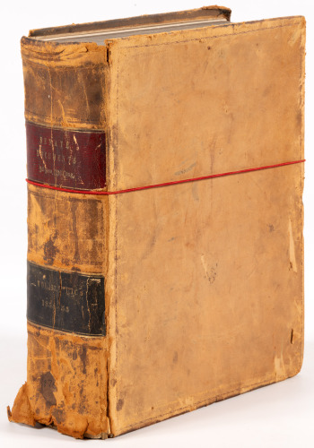
Title: Reports of Explorations and Surveys, to Ascertain the Most Practicable and Economical Route for A Railroad from the Mississippi River to the Pacific Ocean. Made Under the Direction of the Secretary of War, in [1853-55] Author: ** Place: Washington Publisher: Beverley Tucker, Printer Date: 1855-1860 Description: 12 volumes in bound in 13. Extensively illustrated with color lithograph plates of scenic views, black & white lithographs of geological, botanical & zoological subjects (including the hand-colored lithographs of birds), graphs & charts, folding maps, etc. (4to) 28x21.5 cm (11x8½"), uniformly bound in period brown half morocco and marbled boards, spines lettered and decorated in gilt, raised bands, all edges marbled. A matching set of the Senate issue. Complete set of the quarto edition of the massive compilation of Secretary of War Jefferson Davis in the largest concerted effort to map the western frontier of the United States to that time. Four major routes were surveyed, from a northern route terminating at the mouth of the Columbia River to a southern route running through Texas to San Diego. Superbly illustrated with color lithographs of the countryside and native peoples of the regions explored, and with numerous maps detailing areas never before surveyed. This monumental work ranks as a major landmark in the opening of the west. Among the principal contributors were A.A. Humphreys, G.K. Warren, Isaac Ingalls Stevens, J.G. Parke, A.W. Whipple, J.C. Ives, W.H. Emory, and Spencer F. Baird. The important series of lithographic views of the West, from drawings by Richard and Edward Kern, Tom Mix Stanley, Charles Koppel and others, presented to the world some of the first depictions of previously unexplored regions of the West, and some of its newly settled regions. Wagner-Camp notes, "Despite their flaws, these volumes contain a monumental collection of scientific information, geographical, zoological, botanical, geological, of the still mysterious American West. Upon first examination, the volumes seem forbiddingly disorganized... however these faults are amply compensated by the richness of the material within." Howes P3; Wagner-Camp 262-267. The present set was specially bound for the Engineering Department of the United States War Department and, as evidenced by small rubberstamp markings on the title pages, was presumably presented to the Library of the Imperial and Royal Military Technical Committee of the Austro-Hungarian Army (Bibliotek Des K.u.K Technischen Militarkomitee). Matching sets of these reports are quite scarce and a presentation set in a period fine morocco binding exceedingly so. Possibly the finest set to appear at auction. Lot Amendments Condition: Spines a touch sunned, small paper case and shelf numbering labels affixed to spines, some rubbing to bottom edges; light foxing; near fine to fine. Item number: 233105
Title: Reports of Explorations and Surveys, to Ascertain the Most Practicable and Economical Route for A Railroad from the Mississippi River to the Pacific Ocean. Made Under the Direction of the Secretary of War, in [1853-55] Author: ** Place: Washington Publisher: Beverley Tucker, Printer Date: 1855-1860 Description: 12 volumes in bound in 13. Extensively illustrated with color lithograph plates of scenic views, black & white lithographs of geological, botanical & zoological subjects (including the hand-colored lithographs of birds), graphs & charts, folding maps, etc. (4to) 28x21.5 cm (11x8½"), uniformly bound in period brown half morocco and marbled boards, spines lettered and decorated in gilt, raised bands, all edges marbled. A matching set of the Senate issue. Complete set of the quarto edition of the massive compilation of Secretary of War Jefferson Davis in the largest concerted effort to map the western frontier of the United States to that time. Four major routes were surveyed, from a northern route terminating at the mouth of the Columbia River to a southern route running through Texas to San Diego. Superbly illustrated with color lithographs of the countryside and native peoples of the regions explored, and with numerous maps detailing areas never before surveyed. This monumental work ranks as a major landmark in the opening of the west. Among the principal contributors were A.A. Humphreys, G.K. Warren, Isaac Ingalls Stevens, J.G. Parke, A.W. Whipple, J.C. Ives, W.H. Emory, and Spencer F. Baird. The important series of lithographic views of the West, from drawings by Richard and Edward Kern, Tom Mix Stanley, Charles Koppel and others, presented to the world some of the first depictions of previously unexplored regions of the West, and some of its newly settled regions. Wagner-Camp notes, "Despite their flaws, these volumes contain a monumental collection of scientific information, geographical, zoological, botanical, geological, of the still mysterious American West. Upon first examination, the volumes seem forbiddingly disorganized... however these faults are amply compensated by the richness of the material within." Howes P3; Wagner-Camp 262-267. The present set was specially bound for the Engineering Department of the United States War Department and, as evidenced by small rubberstamp markings on the title pages, was presumably presented to the Library of the Imperial and Royal Military Technical Committee of the Austro-Hungarian Army (Bibliotek Des K.u.K Technischen Militarkomitee). Matching sets of these reports are quite scarce and a presentation set in a period fine morocco binding exceedingly so. Possibly the finest set to appear at auction. Lot Amendments Condition: Spines a touch sunned, small paper case and shelf numbering labels affixed to spines, some rubbing to bottom edges; light foxing; near fine to fine. Item number: 233105


Testen Sie LotSearch und seine Premium-Features 7 Tage - ohne Kosten!
Lassen Sie sich automatisch über neue Objekte in kommenden Auktionen benachrichtigen.
Suchauftrag anlegen