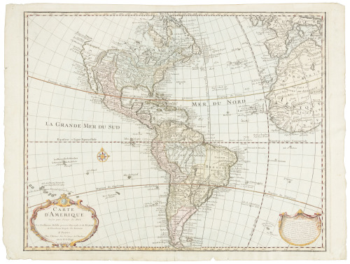
Title: Carte d'Amerique, dressée pour l'usage du Roy. Par Guillaume Delisle premier Géographe de Sa Majesté de l'Academie Royale des Sciences Author: De l'Isle, Guillaume Place: Amsterdam Publisher: Jean Covens & Corneille Mortier Date: 1722-[1755] Description: Copper-engraved map, hand-colored in outline. 48x60 cm. (18¾x23½"). Covens & Mortier's "revised issue of the Amsterdam copper-plate" of De l'Isle's 1722 foundation map, as noted by Tooley. "The plate for this edition is considerably altered and a Latin title printed in large type above the top border. The west coast is continued northward above Cap Blanc to include a large Mer de l'Ouest. Several legends are expanded, for example the note on the Papal line of demarcation now occupies three lines. Mer Pacifique is added to Grande Mer du Sud. Other additions include: Ocean Ethiopien, a note on the shipping off the Grand Bank of Newfoundland, historical notes on Magellanica &c. The interior of N. America, to the west of Hudson's Bay and to the north of the Mississippi has been filled in, e.g. Lake Bourbon which in area rivals the Great Lakes replaces Lac du Brochet. The west end of Hudson's Bay has been closed up and some names added, e.g. C. Churchill, P. Nelson. Halifax is shown and, for the first time in this series, Philadelphia." Tooley, Mapping of America, p.13, No. 4, Plate 3. Lot Amendments Condition: Repaired and strengthened at lower edge and top and bottom of centerfold, still near fine, an attractive and significant map with bright original coloring. Item number: 167330
Title: Carte d'Amerique, dressée pour l'usage du Roy. Par Guillaume Delisle premier Géographe de Sa Majesté de l'Academie Royale des Sciences Author: De l'Isle, Guillaume Place: Amsterdam Publisher: Jean Covens & Corneille Mortier Date: 1722-[1755] Description: Copper-engraved map, hand-colored in outline. 48x60 cm. (18¾x23½"). Covens & Mortier's "revised issue of the Amsterdam copper-plate" of De l'Isle's 1722 foundation map, as noted by Tooley. "The plate for this edition is considerably altered and a Latin title printed in large type above the top border. The west coast is continued northward above Cap Blanc to include a large Mer de l'Ouest. Several legends are expanded, for example the note on the Papal line of demarcation now occupies three lines. Mer Pacifique is added to Grande Mer du Sud. Other additions include: Ocean Ethiopien, a note on the shipping off the Grand Bank of Newfoundland, historical notes on Magellanica &c. The interior of N. America, to the west of Hudson's Bay and to the north of the Mississippi has been filled in, e.g. Lake Bourbon which in area rivals the Great Lakes replaces Lac du Brochet. The west end of Hudson's Bay has been closed up and some names added, e.g. C. Churchill, P. Nelson. Halifax is shown and, for the first time in this series, Philadelphia." Tooley, Mapping of America, p.13, No. 4, Plate 3. Lot Amendments Condition: Repaired and strengthened at lower edge and top and bottom of centerfold, still near fine, an attractive and significant map with bright original coloring. Item number: 167330


Testen Sie LotSearch und seine Premium-Features 7 Tage - ohne Kosten!
Lassen Sie sich automatisch über neue Objekte in kommenden Auktionen benachrichtigen.
Suchauftrag anlegen